

The rain in Spain falls mainly on the plane
After months of dry, hot & humid weather the
Gota Fria has returned with gusto
From the Costa Blanca down to the Costa Almeria we have all seen tremendous thunder storms with rain in abundance.
So far this looks mainly to have done what it is supposed to have done by running through normal and natural pathways. Last night Pueblo Laguna roads were evacuated as a precaution & after close inspection by the police with help from the helicopter services checking local mountains the all clear passed.


The weather however is forecast to be similar over the next few days, so please take care and stay safe.
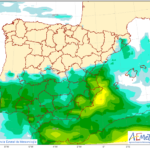
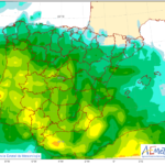
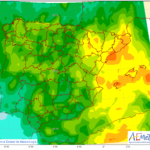
Friday 15 mm rainfall – Saturday 40 mm rainfall – Sunday 25 mm rainfall
“Gota fría, or “cold drop”, is a weather phenomenon often occurring in the Spanish autumn. It is experienced particularly along the western Mediterranean and as such, most frequently affects the east coast of Spain (although it is by no means limited to this area).
Gota fría is the name given to the storms. These most commonly take place after the summer months when the sea temperature is still high, but the temperature in upper airstreams suddenly drops. The warm air, saturated with water vapour, rises and cools too quickly when meeting the upper airstreams. The result is extremely intense rainfall, accompanied by high winds (up to 140 km/h), hail and thunderstorms.
A gota fría is more intense on or close to the coast, and can be powerful enough to uproot trees.”
We are at Yellow Alert for Rains and Storms in Murcia, Almeria & South Costa Blanca areas!
Have you any pictures from the recent rains? Send them to webmaster@euronews247.com..
Forecast http://www.aemet.es/


